RED RIVER GORGE SPORTS MAP   THE SPORTS | THE MAP | PURCHASE

TRAIL RUNNING | Trail meanders through 700 feet of elevation relief, so you can suffer challenging aerobic excercises in cool, serene forests. Backpacking & Camping go here...

ROCK CLIMBING | World-class sport and trad climbing can be found in the Red. This map locates 50 climbing areas, including popular & obscure destinations.
MOUNTAIN BIKING | The Southern Gorge offers miles of exploration on old Forest Service & resource extraction roads. For The Best Singletrack go here...
PADDLING | The Red River is a National Wild and Scenic River. The Scenic River is over 10 miles with Class I rapids and the Wild River is 10 miles with Class III.
 

The Red River Gorge Sports map is printed at 18 x 24 inches on a 100lb sheet and folded into a resealable, 7 x 12 inch plastic bag. An overview map is provided as an inserted cover.

The map has a coordinate grid for GPS navigation, estimated cliffline, and a shaded-relief map that shows topography. Contact information for all overnight accommodations is provided.

VIEW SAMPLE (200k)
DOWNLOAD OVERVIEW MAP
Listen to audio about climbing
More downloads...

some 
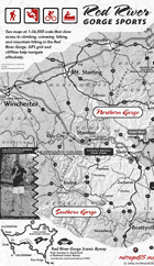
PLACES MAPPED on the NORTHERN GORGE MAP: Clifty Wilderness, Big Branch Canoe Launch, Purple Valley, Pistol Ridge, Funkrock City, Auxier Ridge, The Sheltowee Trace, Sky Bridge, Wildcat Wall, The Red River Narrows, Blackburn Rock, Osborne Bend

some PLACES MAPPED on the SOUTHERN GORGE MAP: Pendergrass-Murray Recreation Preserve, the Motherloade, Darkside, Solar Collector, Big Sinking Creek, Big Bend Ridge, Muir Valley, Shady Grove, Fixer, Global Village, Fitchburg Furnace, Torrent Falls


Last Updated on July 30, 2004