We like to explore
Our trail maps cover our favorite wilderness and public lands in Kentucky, Tennessee, Virginia, and North Carolina. We make maps that show trails, elevation contours, aerial photography, and GPS grids for precise navigation.
Sheltowee Trace
A 354-mile backcountry trail that spans the Daniel Boone National Forest and the Big South Fork.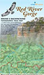
Red River Gorge Backpacking Map
Enjoy ruby flushed sunsets sweeping through hemlocks and fresh rhododendron blooms as you hike through murals of eroded sandstone.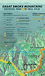
Great Smoky Mountains Trail Atlas
This innovative atlas contains GPS trail maps with tree canopy type and a gazetteer of scenic sites.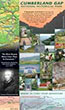
Cumberland Gap Trail Map
A unique map that shows trail elevation profiles for the park's popular loop and long-distance hikes.Bluegrass Trails
Explore the trails in central Kentucky with this online, interactive map. We're in development adding more trails, descriptions, and photographs.


Our Favorite Hikes
If you visit this site often, you likely have a favorite map app on your phone. I certainly do and I have installed dozens of apps over the years. Most focus on placing your location as a dot on the map.
The dotAny map app that shows your location as a dot on the map fosters a dependence on your...
Our Blog
Interactive web maps have come a long way over the years. First we had slippy maps using raster tilesets – they’ve been around for about twenty years and are incredibly durable. However, once the tileset is rendered, it’s not easy to change the look of the raster image. You will need to render ...
Our Clients' Maps
Class mapping project
Web page for student maps
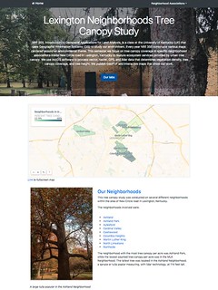
NRE 355, Introduction to Geospatial Applications for Land Analysis, is a class at the University of Kentucky (UK) that uses Geographic Information Systems (GIS) to study our environment. Every year NRE 355 constructs various maps centered around an ...
