 |
||||
|
||||
|
||||
|
||||
| HOME | SPECIFICS | SAMPLES | BACK | ||||||
| CORE of videoGIS: The Libraries
All layers in the videoGIS library represent individual geographic features such as roads, rivers, county outlines, text labels, and urban areas. With 10-30 layers to orchestrate per library, you have complete artistic control of your final map image. You can get as complex, or as simple, as you desire. Layers have registration marks so that all layers within one library overlay precisely together. outrageGIS organizes the libraries by state and continent; however, you can assemble any number of layers by any region you wish.
LAYERS in videoGIS Libraries
COVERAGE of videoGIS Libraries Currently, Detailed State Libraries are offered for Kentucky, and Basic Libraries are offered for the North American Continent.
ACCESS to videoGIS Web Support Users of the videoGIS package receive privileged access to a host of web resources. From updates, user message boards, to special mapping services, videoGIS users will find a total solution to their mapping needs.
CUSTOM MAPPING with videoGIS In addition to the libraries and web support, outrageGIS offers free and reduced rate custom mapping services to videoGIS users. The goal of outrageGIS is simple: to help videoGIS users make the best possible map image for any occasion. videoGIS users get a subscription to a free bimonthly mapping service, and receive significant discounts for animations and specialty mapping services.
ORDER your videoGIS Every user has custom needs in their mapping program and outrageGIS wants to accommodate those needs. Depending on the area of coverage, number of layers, and type of licensing exclusivity desired, prices vary for videoGIS packages. Please submit an order form for quotes, or email us for more elaboration on videoGIS packages, or outrageGIS mapping services. |
|||||||||
|
outrageGIS mapping PO Box 2054 Lexington, KY 40588 859-255-9293 |
|||||||||
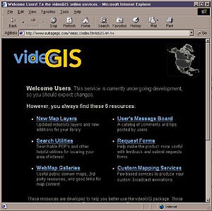 The image to the left is a screen capture from the videoGIS user's welcome page. Links from this site provide a range of tools that only you, as a videoGIS user, can implement into your production workflow.