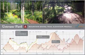
In tribute to Bike Lexington month, we’ve made a new map for beginning mountain bikers. If you’re new to trail riding and want tight, banking turns on fast, easy trail, then visit’s Lexington’s Veteran’s Park.
We created this map as a demonstration of small-area map making. We first walked the trail with a Trimble GPS unit this past winter to accurately locate the trail. We then used Kentucky’s new aerial photography and LiDAR elevation data to make 5-foot contours and heads-up digitized canopy coverage. We also pulled in the impervious and waterbody layers from the new Open Data Portal from LFUCG. This is all GIS data that has been created and/or made available in the past six months.
 More nerd alert. The recent availability of small-scale mapping data is awesome. We thought we’d try to see how good this data is and make trail elevation profiles, which is included with this map. While the elevation profile is not perfect at this scale (with perhaps a +/- 8 ft height error for any given point on the profile), it gives a good distance measurement and represents well the relative slope of the trail. Since the vertical scale is not the same as the horizontal scale, the profile exaggerates the pumps & humps a rider faces…which means, the slopes are exaggerated.
Enjoy and tell us what you think.


Speak Your Mind
You must be logged in to post a comment.