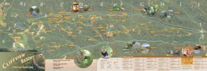
We’re almost finished with a 38″ x 13″ map of cabins and ziplines in Cliffview Resort. This is an unusual map, since it is a bird’s eye view with latitude and longitude as the index grid for locating cabins and other destinations. The base map is an ArcGIS terrain dataset with National Agriculture Imagery Program (NAIP) aerial photography draped over a rendered TIN surface in ArcScene. The maps was then composited and illustrated in Photoshop and Illustrator.
"Everybody needs beauty as well as bread, places to play in and pray in, where nature may heal and give strength to body and soul."
-John Muir
Explore
Your cart
outrageGIS mapping
We are a small map studio that lovingly crafts all of the maps sold on this site. We dedicate our mapping and photography to parks we feel are treasures of public wilderness.
outrageGIS mapping
PO Box 2054
Lexington, KY 40508
News
Copyright © 2025 · outrageGIS mapping · All Rights Reserved · Admin


Leave a Reply