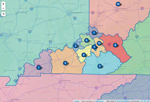
A slippy map that shows alumni districts for the University of Kentucky. A shapefile of the districts was simplified with polygon edges snapped to align and then converted to a GeoJSON file. Tried to convert to TopoJSON with the hope to minimize file size, but unfortunately with little luck. District centroids were exported and converted to marker icons. A simple example of open source mapping.
"Everybody needs beauty as well as bread, places to play in and pray in, where nature may heal and give strength to body and soul."
-John Muir
Explore
Your cart
outrageGIS mapping
We are a small map studio that lovingly crafts all of the maps sold on this site. We dedicate our mapping and photography to parks we feel are treasures of public wilderness.
outrageGIS mapping
PO Box 2054
Lexington, KY 40508
News
Copyright © 2025 · outrageGIS mapping · All Rights Reserved · Admin


Leave a Reply