Rock Creek Loop, a cool summer hike

Twin ArchesHiker Big South Fork Map
Distance: 6.6 Miles round-trip
Difficulty: ++
Scenic Views: +++
Elevation Relief: 520ft ^
Ownership: Big South Fork, NPS

Big South Fork Trail Map: $12

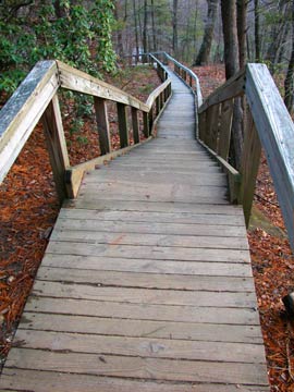
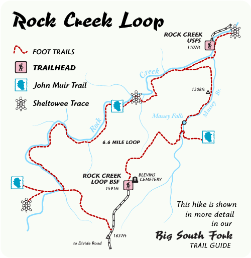
Hike the scenic crossroads of the John Muir Trail and Sheltowee Trace. Rock Creek Loop is a 6.6-mile loop in our Big South Fork Guide. Half of this loop follows the cool waters of Rock Creek, a trout stream with small stretches of swift water and deep pools for summer refreshment.

Hikers weave through a forest dominated by old, stately Hemlock and American Beech trees with grassy, wildflower areas along the stream bank. The trail is a rugged footpath with a bridge across Massey Branch. Numerous backcountry campsites along the loop offer great weekend backpacking options with side trail options into Pickett State Park and the Daniel Boone National Forest.

Rock Creek Loop

Gray’s Arch Trail

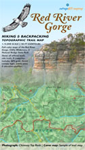
Hiker Red River Gorge Backpacking Map
Distance: 3.4 Miles loop trail
Difficulty: ++
Scenic Views: ++++
Elevation Relief: 400ft ^
Ownership: Daniel Boone National Forest, USFS

Red River Gorge Backpacking Map: $14

This well-used and maintained trail is the first (or last) segment of the challenging 10-mile Power Loop Hike. Starting at Gray’s Arch trailhead parking (map) walk a short quarter-mile double-width foot trail to an intersection with the Martin’s Fork Trail. Continue to the right passing the small field on Butterfly Hill. About a mile into the hike, you’ll find a few ridge top campsites west of the trail. An unmapped trail follows a narrow ridge above Left Flank climbing area.

[Read more…]

Swift Camp Creek Trail

Hiker Red River Gorge Backpacking Map
Distance: 7.8 Miles one-way
Difficulty: +++
Scenic Views: +++
Elevation Relief: 500ft ^
Ownership: Daniel Boone National Forest, USFS

Red River Gorge Backpacking Map: $14

The best trail in the Clifty Wilderness Area. Starting at Rock Bridge trailhead and hiking down Swift Camp Creek as it cuts a steep, narrow gorge, you’ll experience the least-visited area in the Red River Gorge. Trail often skirts cliff edges and side trails wind down to the creek and cool water in the summer heat. Nice campsites exist near Pooch’s Turtle Falls, Don Juan’s Garden, and Steamboat Rock.
[Read more…]

Tower Rock Trail

Hiker Red River Gorge Backpacking Map
Distance: 1 Mile loop
Difficulty: ++
Scenic Views: ++
Elevation Relief: 200ft
Ownership: Daniel Boone National Forest, USFS

Red River Gorge Backpacking Map: $14

Tower Rock Trail is an easy hike to a monolithic outcropping of eroded sandstone.

View of Tower Rock side with moon
[Read more…]

Chimney Top & Princess Arch

Hiker Red River Gorge Backpacking Map
Distance: 1 Mile one-way
Difficulty: +
Scenic Views: +++
Elevation Relief: 100ft
Ownership: Daniel Boone National Forest, USFS

Red River Gorge Backpacking Map: $14

Chimney Top Rock

Chimney Scenic Picnic Area is the start of the two shortest, but most rewarding trails in the Gorge. Both trails visit splendid overlooks and many additional miles of side trails connect with picnic area. The camping area is a nice ridge to explore.
Princess Arch
[Read more…]

Sheltowee Trace & Bison Way Loop

Hiker Red River Gorge Backpacking Map
Distance: 5 Miles loop
Difficulty: ++
Scenic Views: +++
Elevation Relief: 300ft ^^
Ownership: Daniel Boone National Forest, USFS

Red River Gorge Backpacking Map: $14

Overlook in fall

The Sheltowee Trace spans the entire length of the Daniel Boone National Forest and a portion of the Big South Fork in Tennessee. The section through the Red River Gorge is one of the most spectacular, with this short segment visiting some of the most impressive overlooks and challenging side trails. Indian Staircase is an unofficial trail that climbs up a steep set of cliff ledges and can be found on the printed map. Although this loop uses part of a paved road, hikers have a chance for a short walk to the Red River suspension footbridge, the longest in the forest.

Suspension Bridge

Gladie Welcome Center
[Read more…]

The Rough Trail

Hiker Red River Gorge Backpacking Map
Distance: 8 Miles one-way
Difficulty: +++
Scenic Views: ++++
Elevation Relief: 500ft ^^^^
Ownership: Daniel Boone National Forest, USFS

Red River Gorge Backpacking Map: $14

Rhododendron grove along Parched Corn Creek

The Rough Trail is longest trail through the heart of the Red River Gorge. Many side trail options allow hikers to increase mileage and create additional loops. For the ultimate Gorge experience, connect this trail with the Swift Camp Creek Trail.

Junction of Rough and Swift Camp trails
[Read more…]

Wildcat Trail Loop

Hiker Red River Gorge Backpacking Map
Distance: 6 Miles loop
Difficulty: +++
Scenic Views: ++
Elevation Relief: 400ft ^^
Ownership: Daniel Boone National Forest, USFS

Red River Gorge Backpacking Map: $14

Don Juan’s Garden

The Wildcat Loop begins at the eastern terminus of the Rough Trail. The trail descends into Sons Branch while passing large stands of rhododendron and hemlock trees. At the intersection with Swift Camp Creek, hikers can cross the creek to find large camping areas. After about a mile hiking up Sift Camp, Don Juan’s Garden presents a majestic grove of hemlocks along an impressive cliff known as Wildcat Wall. After returning to the ridge on trail #228, the Wildcat Trail, hikers can find abundant lady slippers in spring.

Wildcat Wall
[Read more…]

Rock Bridge Loop

Hiker Red River Gorge Backpacking Map
Distance: 1.5 Miles loop
Difficulty: +
Scenic Views: ++
Elevation Relief: 300ft ^
Ownership: Daniel Boone National Forest, USFS

Red River Gorge Backpacking Map: $14

Rock Bridge

Rock Bridge Scenic Picnic Area is the start and end for this easy hike. This trail descends into the Swift Camp Creek drainage area and visits Creation Falls, one of the largest falls in the Gorge, and Rock Bridge, the only arch with a stream flowing beneath it.

Creation Falls
[Read more…]

Ridge Trail at Cumberland Gap NHP

Buy this mapHiker Hiker Cumberland Gap Map
Distance: 16 Miles round-trip from the Civic Park trailhead at Ewing
Difficulty: +++
Scenic Views: ++++
Elevation Relief: 2,000ft ^^
Ownership: Cumberland Gap, NPS

Cumberland Gap Trail Map: $14

Camp Hensley

The Pixel Team hiked up to Hensley Settlement after the Southeastern Foot Trails Conference and it was a fantastic, sublime experience. Sherman Hensley hiked up this mountain in 1903 with his pregnant wife and all of the tools and livestock they could drive. They saw a large, flat expanse on the mountain summit and carved out a pioneer homestead. Two backcountry camps are within 0.5 miles of this historic community.

Ridge Trail overlook

[Read more…]

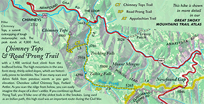
Chimney Tops and Road Prong Trail

Appalachian TrailHiker Great Smokies Trail Atlas
Distance: 9 Miles round-trip from trailhead
Difficulty: +++
Scenic Views: +++
Elevation Relief: 1,800ft ^^
Ownership: Great Smoky Mountains, NPS

Great Smokies Trail Atlas: $14

As you drive from the Sugarlands Visitor Center on Newfound Gap Road, you’ll catch glimpses of the Chimney Tops, a summit outcropping of tough, erosion resistant metamorphic rock. Originally deposited as sedimentary rock, such as shale, sandstone, and siltstone over 500 million years ago, the rocks that make the mountains here first experienced metamorphosis becoming a hard, slate-type rock, and then mountain building forces to form the folded and faulted Appalachians, with peaks as high as the Rocky Mountains. Today, after 200 million years of erosion, Chimney Tops stands at 4,800 feet and roughly a 1,400 vertical foot climb from the trailhead below. As you walk and climb along the last quarter-mile of the ridge, you’ll clearly see the bedrock tilting down to the right, evidence of the great tectonic forces that thrust up the mountains that you’ll admire around you from this inspiring prominence.

The name the Cherokee Indians gave Chimney Tops, was Forked Antler. As you scan the ridge from valley overlooks, you can easily imagine the shape of a deer’s antler. The first 3/4 mile of this hike follows Road Prong, a stream that reaches the crest line of the Smokies. If you continue up Road Prong trail, you’ll hike one of the oldest trails in the area. Long used as an Indian path through the mountains, the path was expanded during the Civil War to move troops through the Smokies connecting Smokemont, North Carolina with Gatlinburg, Tennessee. The road was called the Oconaluftee Turnpike and it passed through Indian Gap at the summit. Today the summit is marked with the Appalachian Trail and Indian Gap is called Luftee Gap.

A note about climate and slope in the mountains. The high mountains in the area form steep, thinly soiled slopes, which are historically prone to landslides after extended periods of heavy rain. You’ll see many scars and debris fields from previous landslides as you hike to the summit. And the Smokies know plenty about rain: the summit line receives on average more precipitation anywhere east of the U.S. mountain west coast.

Because of the elevation, the temperature is similar to Canada, but because of the relief (over a mile above surrounding foothills), the precipitation pattern is more typical marine, creating colder and wetter conditions. Because of the proximity to Gulf and Atlantic tropical air masses, summer storms, especially remnants of hurricanes, can produce torrential rain events. These storms increase flash flooding and landslide hazards. In the late winter, polar air masses from the north can create an upslope flow forcing up moisture rich air and produce heavy snowfall. With an average of 5-8 inches of rain per month, streams can be difficult to cross anytime of the year. Please contact the park service before any backcountry trip.

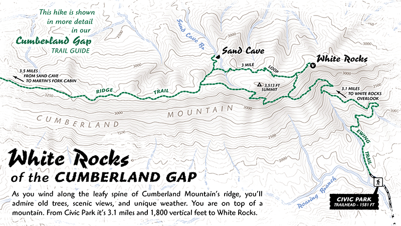
White Rocks and the Ridge Trail

White RocksHiker Hiker Cumberland Gap Map
Distance: 16 Miles round-trip from trailhead
Difficulty: +++
Scenic Views: ++++
Elevation Relief: 1,800ft ^^
Ownership: Cumberland Gap, NPS
Google to trailheads

Cumberland Gap Trail Map: $12

White Rocks Overlook

The White Rocks overlook to Martin’s Fork on the Ridge Trail is the “power-date” of overnight trips in Cumberland Gap. You have a massive ascent, a capital view, and great camp at Martin’s Fork rustic cabin. The stadium rockhouse Sand Cave helps cool your engines and spirit. Trees bent dog-legged by mountain top winds great you like old friends. You are on the Ridge Trail.whiterocks-hike-rgb-web-lar.gif

[Read more…]

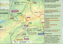
Cumberland Gap Trip Planner

Trip Planner Great Backcountry Trips at Cumberland Gap
This webpage with zoomable map shows awesome backcountry trips in color-coded loops, all of which use some segment of the Ridge Trail. Trips are organized as weekend excursions with suggested camping and water access. The map is a simplified version of the full topographic trail guide found here. The full map also contains the useful elevation profiles for trails.

The page also has links to audio about recreation in Cumberland Gap. The audio is part of the free audio driving tour we produced entitled, The First Frontier Audio Driving Tour. The entire tour can be download for free at firstfrontier.org.

Hiker Hiker Cumberland Gap Trail Guide
Ownership: Cumberland Gap National Historical Park, NPS
Google to trailheads

Cumberland Gap Trail Map: $12

Interactive maps: 3D and 2D

Visit the Cumberland Gap trail planner for your next backcountry trip.

Tater Knob Trail – Pioneer Weapons

Tater Knob Fire Tower stairs

Sheltowee Trace North Trail Map: $26

This is an essential Cave Run Lake experience: hiking to the top of Tater Knob. You can’t say you’ve ‘done’ Cave Run, unless you’ve watched the sunset from this last-standing fire tower in the Daniel Boone national forest. Built in 1934, the tower was decommissioned in the 1970’s when aircraft replaced fixed observation points.

[Read more…]

Gibson Gap – Ridge Trail – Hensley Settlement

Hensley SettlementHiker Hiker Cumberland Gap Map
Distance: 23 Miles round-trip from Wilderness Road Campground
Difficulty: +++
Scenic Views: ++++
Elevation Relief: 2,100ft ^^^
Ownership: Cumberland Gap, NPS
Google to trailheads

Cumberland Gap Trail Map: $12

Trails in Hensley settlement

Sherman Hensley hiked up this mountain in 1903 with his pregnant wife and all of the tools and food-on-foot he could drive. They saw the large meadow that would bear the Hensley name and carved out a pioneer homestead. The Gibson family later joined the settlement and together they lived on the mountain, even after the park purchases their land until Sherman left in 1970. [Read more…]

0

Your Cart