El Niño to make the mountains colder and drier this winter

Predicting climate in the old days relied upon observing cues in nature. The Farmers’ Almanac finds that people looked at woolly worms in late summer in get a sense of winter. The more black hairs on the worm, the colder and wetter the winter. Of course woolly worms come in all configurations of black and orange colorings so how could a worm’s coat predict winter? It can as an analogy;  you look at the forecast to decide which coat you’re going to wear before leaving home. I think you would want to wear a black coat as opposed to a white coat on a very cold and sunny day to maximize the amount of solar energy you could absorb. Woolly worms just plan far ahead.

Today we track global changes in wind patterns and sea surface temperatures to predict weather conditions. NOAA’s Climate Prediction Center has issued a climate forecast for this winter based on the El Niño pattern emerging in the Pacific Ocean.

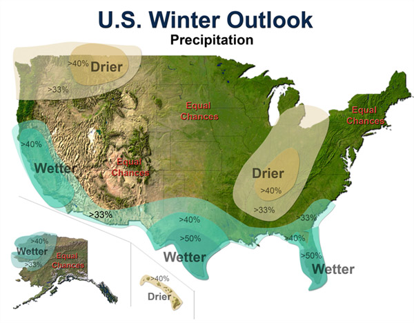
Below are winter predictions for the U.S. indicating greater or lesser chances for departures in average winter temperatures and precipitation.
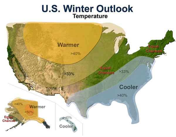
temps

precip

El Niño is a departure from average sea surface temperatures created by a change in the intensity and direction of equatorial winds. In a normal period, strong easterly trade winds blow across the Pacific and upwell cold, nutrient rich waters on the west coast of South America. These same winds also pile up water in the western Pacific so that the sea surface is about 2 feet higher at Indonesia than at Ecuador.

Normal Sea Surface Temperatures in °C

In an El Niño cycle, the winds are not as intense and warmer sea surface temperatures extend further to east. This change has a global impact on weather with increased precipitation on the west coast of South America and the south & east coasts of North America. Warmer than normal conditions also occur at higher latitudes in North America and over the Pacific ocean.
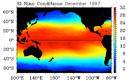
El Niño Sea Surface Temperatures in °C

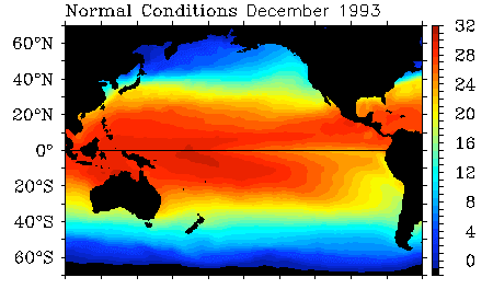
El Niño Sea Surface Temperatures in °C

First freezing night in the Great Smokies

Overnight the temperature dropped to 25° F at the Newfound Gap weather station, elevation 5,000 ft. Mt LeConte at 6400 ft above sea level recorded a low temperature of 31° F.  The slight warming at 1,400 ft higher in elevation is caused by a temperature inversion that most frequently happens in autumn mornings.

The lowest temperature recored at Mt. LeConte for September 29 was 24° F and that happened in 2003. The coldest night ever recorded since 1988 was -22° F, which occurred last February 4.

Station reports for 7:30 am, September 28 – 7:30 am, September 29:

STATION             ELEV    HIGH    LOW     PCPN    SNOW DEPTH
SUGARLAND CENTER    1600     75      45     0.00
NEWFOUND GAP        5000     62      25     0.00
CADES COVE          1900     73      44     0.00
OCONALUFTEE         2040     79      42     0.00
MOUNT LECONTE       6400     57      31     0.01

http://www.outrageGIS.com/weather/grsm

All weather cams are up

Look Rock, Sept. 24

Look Rock, Sept. 24

After a few months of intermittent outage, all four weather observation cameras for the Great Smoky Mountains National Park are now operational. We archive full-day animations for 3 webcams and the visible satellite view of the park every day at:
http://www.outragegis.com/weather/img/animation/yesterday
.

For previous days, you can access other days by replacing “yesterday” with the 6-digit year month day combination. For example, for September 24, 2009 replace “yesterday” with “090924”and create this link:
http://www.outragegis.com/weather/img/animation/090924.

For highest resolution images, just click on the preview images.

The two National Park cameras are located on Look Rock and Purchase Knob. Look Rock camera overlooks most of the park. The two National Forest cameras, Cold Mountain and Joyce Kilmer Wilderness, overlook small portions of the park.

Now let’s watch fall pass in the mountains!

Animations of the Atmosphere

As a lover of the atmosphere and sun, I want to see how light and sky change over the course of the day. I also want to see how large-area weather events, such as the passage of a front, impact different places in the Great Smoky mountains. The inspiration behind this page was a desire to record weather changes at different elevations on a mountain and to help the photographer in me better understand a secretive and dynamic landscape.

Enter Yesterday: a site of prior-day animations of federal web cams and satellite imagery located here at http://www.outragegis.com/weather/img/animation/yesterday. Note this page always shows conditions for the prior day since they are full-day timelines.

The Great Smokies have about one mile of vertical relief and weather conditions can be dramatically different depending on your elevation. Whatever it’s a line of thunderstorms or fog in the valleys on a calm morning, this is a visual record of evolving conditions…only of course it happens during daylight. For the weather nut who likes to take it a step further, the page gives data from park’s 5 weather stations for the same day….and it’s all archived.

How was it done? After tinkering with ImageMagick and FFmpeg, I made a script that creates full-day animations of the webcams in the Great Smokies and visible satellite images from NOAA. What will it become? Consider it a visual archive of the atmosphere and movements of the Sun in the Great Smokies. Any suggestions are welcome.

Some notes for updates: I haven’t fully utilized the flash embedded video (see the two samples below, top is animated gif and below is embedded flash video). The problem is setting animations in sync together, e.g., sun rises at the same time in all movies. With an animated .gif, I think you simply need to refresh your browser after all of the images are loaded to get a partial sync. A better solution is out there. I can also increase the sampling rate for smoother play; now it’s two samples an hour.

Weather map and webcam animation for the Great Smoky Mountains

Weather map and webcam animation for the Great Smokies


[flv:http://www.outragegis.com/weather/img/animation/090603/PurchaseKnob.flv 400 290]

These are also archived, so if you go to the smokies for a backcountry trip, you’ll be able to find your days here.

It is all about Light: a photographers dream

The past day’s weather has included periods intense light and shadow from very low, broken stratus & cumulus clouds. Rays of love from god shine from heaven through parted clouds; and there was plenty of love in the mountains. Even in these low quality webcam images, you can see golden rays of light and clearly defined ridges. Now what if you were there with a serious camera.

Though the weather overall has been chilly and uncomfortable, it does give some memorable vistas. The more diffuse stratus clouds in the western mountains were lower in altitude and created softer light.

Moon Rise
View from Purchase Knob

A Tale of Two Smokies

Visible Sat April 15, 2009. We see two very different Smokies today and the highest peaks in the southern Appalachians provide an atmospheric boundary.

On the west side of the mountains we see low dense stratus clouds, but on the east side we have clear skies. As the atmosphere is uplifted over the the highest ridge of mountains there’s cooling and abundant cloud formation. That’s half the story.

The winds are form the northwest and the Smokies (along the Tennessee/North Carolina stateline) provide the highest barrier the winds must cross over. On the leeward side, as the winds cross over the mountains, they descend, warm, and prevent cloud formation especially just east of the summits.

Link to more: http://pixel.outragegis.com/v/weather_maps/090415_TwoSmokies/
These images and animation show a textbook situation of topographic control of weather, but over a very large area.


Easter Morning Sunrise

Weather in the Smokies this spring has been very active. Just last week, Mt. LeConte had 14 inches of snow. This morning the sun rose as a golden fireball that lit the mountain ridges in clear relief. Mt LeConte is the peak at the sun’s 4 o’clock position. Over six inches of snow lingered at the highest elevations for a few days. May has given measurable snowfall.

Moon Rise
View from Look Rock

Great Smoky NP caves and mine shafts closed to public

From the National Park’s website
Contact: Bob Miller, (865) 436-1207
In response to a growing concern about a new malady that has killed an estimated 400,000 bats in the Northeast, managers at Great Smoky Mountains National Park have closed all of its caves to public entry until further notice.

According to biologists from the U.S. Fish and Wildlife Service, a condition called White-nose Syndrome (WNS) is taking a heavy toll on bats that hibernate in caves and mines in nine states from Virginia north to New Hampshire. WNS is named for a white fungus that shows up on the faces of bats, including the endangered Indiana Bat. The Indiana bat has been recorded in the Park and is among several species of special concern relative to this disease.
The disease causes bats to come out of hibernation severely underweight to the point that they often starve before the insects on which they feed emerge in the spring. Once a colony is infected with the fungus, it spreads rapidly and may kill up to 90% of the bats within that cave in one season.

Great Smoky Mountains National Park Wildlife Biologist, Bill Stiver said, “Biologists are still uncertain about the cause of WNS in bats. However, it is believed to be transmitted from bat to bat but also may be inadvertently transported from cave to cave by humans. It has not yet arrived in Tennessee or North Carolina, so we are closing all our caves to reduce the odds of the fungus hitching a ride to our protected caves on a caver coming from a state where it is already established.”

“The Park is closing its caves in response to a recommendation from the Fish and Wildlife Service.” Stiver continued, “That closure advice does not apply to commercial tourist caves, but Fish and Wildlife is planning on working with commercial operators to minimize potential for spread from those sources. There is no known human health risk related to WNS.”

Park managers say that the Smokies has 17 caves and two mine complexes that are now closed under the advisory and that a permit has always been required to enter them. No permits will be issued and violators face fines of up to $5,000 or six months imprisonment.

More information on the disease and this closure is available at  http://www.nps.gov/grsm/naturescience/caves.htm

http://www.nps.gov/grsm/naturescience/caves.htm

Fire in Cades Cove

Controlled burning will impact Cades Cove through April. From the park’s website: “Fire managers at Great Smoky Mountains National Park plan to begin conducting a series of controlled burns of fields in the interior of Cades Cove on Tuesday March 24, 2009, if weather conditions permit. Park managers plan to burn three to seven different parcels totaling up to 300 acres from now until May 1.”

Moon Rise
View from Look Rock

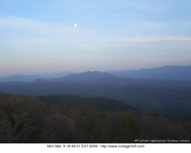
March Moon Rise

Tonight at 10:28 P.M. we will have our March full moon, the last full moon of winter. Full moons throughout the year have names given by early settlers and Native Americans to indicate important seasonal activities…such as a Harvest Moon and Hunter’s Moon.

The March full moon is know as a Worm Moon in the Farmer’s Almanac, for the warming of the soil and emergence of earthworms that herald the return of robins and spring. Also known as a Sap Moon for rising maple tree sap, a Lenten Moon for catholic settlers, and a Crow Moon for the cawing of crows that indicate the end of winter.

Below are photos of the moonrise above the Great Smoky Mountains. The far mountain peak the moon rises over is Mt. Le Conte.
Moon Rise

[Read more…]

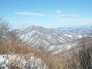
Late winter storm in the mountains, March 2

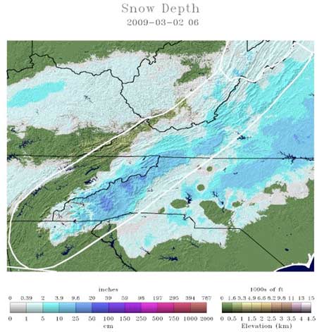
Visible SatA classic weather scenario unfolded over the weekend. A strong low pressure system, located just southeast of the Great Smokies, moved along the eastern coast and left up to a foot of snow in the mountain summits to the east of the Smokies. The northeastern states received the highest snowfall totals from this storm though records were set in southern states.

Most of the snow that falls in the mountains, and especially at lower elevations, occurs during these type of storms. About 50% of snowfall at the highest elevations happens during a strong upslope flow, typically coming off the Great Lakes. These conditions bring heavy snow at the top while little at the bottom. Here mountains create weather by uplifting the atmosphere as it’s forced over the crest of the Smokies.


Snow depth and the darkest blues are 10″-20″ depths.


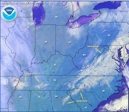
Satellite image of snow cover, from March 2

The Cold Mountain web cam had a thick layer of ice obscuring the blanket of snow left by the storm indicating a mixed bag of precipitation. The storm was accompanied by a strong high pressure located to the northwest and brought bitterly cold conditions after the low pressure moved northeast.


Cold Mountain web cam after some ice melted.
Mt. LeConte had 7 inches of snow and was -4° F Monday morning. Mountains to the east received 12″+ of snow. Most of the snow that fell in the Piedmont region of the Carolinas quickly melted under the March sun. The snow pack in the mountains is much colder and will survive longer especially in deep north-facing valleys.

March often sees big snowfalls in the mountains. Hikers in the highlands should plan for rapidly changing weather conditions with 20-30° F temperature ranges with wet, windy, and cold as company.


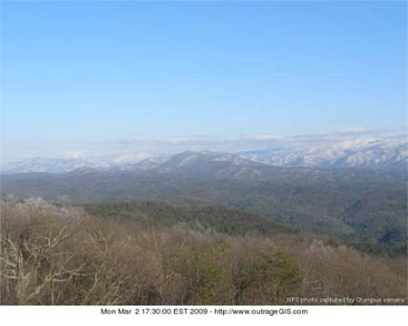
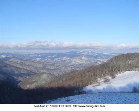
Look Rock web cam looking at Thunderhead Mt. with an obvious snow fall at higher elevations.


Purchase Knob web cam looking northeast over the mountains.Current weather at: http://www.outrageGIS.com/weather/grsm

New outrageGIS Weather Station Features

Visible SatWarm weather is approaching and I thought it would be great to have more web cams and animations to watch the unfurling of Spring and severe weather.

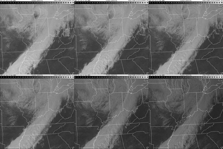
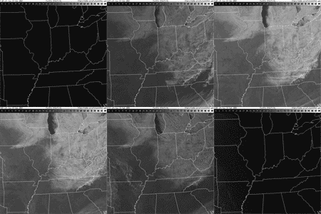
The animation to the left is the visible light spectrum from the GOES satellite and shows a cold front passing over Kentucky this past Saturday. I have assembled a few scripts to output a daily animation from dawn until dusk at four frames per hour.

Each frame is 640 pixels square, so each daily animation is about 8-16 megabytes, depending on the length of daylight. I’m working on automating the output to a .flv movie which would be easier on bandwidth. View a large-version snippet of this of this animation here. As I get the file sizes smaller, these animations will be incorporated into the weather page.
What I find most exciting about these animations is that they are photographs. We know weather and clouds from ground level of course, but to see a corollary from space I think helps a photographer understand the movement of clouds and how they filter sunlight. Though it’d be hard to use these animations to predict future light conditions beyond a few hours, they are helpful in understanding how the atmosphere moves and, in retrospect, what cloud cover is associated with which weather conditions.

How about a full day of photographs?090222

The animation to the right is a full-day digest from Sunday. It shows the snow cover and lake effect snow machine impacting the Appalachians. The full animation is 9 megabytes and can be view here. Note the clearly defined line of cloud cover and snow over the mountains that straddle the TN-NC state line. To the east you can see Mt. Mitchell and its orographic uplift.
Two New Web Cams

Our current NPS web cams Look Rock and Purchase Knob both look east. I incorporated two forest service web cams, Joyce Kilmer and Cold Mountain, which both look west. Though they are not in the park, they are useful in getting a panoramic real-time view of the Great Smokies. All of these web cams can be found on our Great Smokies weather page: http://www.outrageGIS.com/weather/grsm.

Morning in the Great Smokies

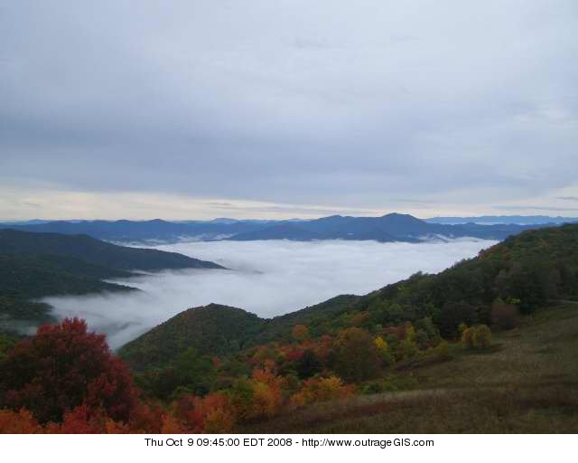
Fog below Purchase Knob on the morning of October 9, 2008

Release of the Great Smoky Mountains Trail Atlas

On July 4th we released a trail lover’s and backpacker’s atlas for a wild & historic national treasure, the Great Smoky Mountains National Park. Our trail atlas was designed for the modern trail user equipped with a GPS, but we focus our cartography on showing the rugged, historical, and ecological character of the park. These maps are beautiful, easy to read, and provide a pleasure as you wander over the pages and discover a new Smokies.

[Read more…]

Trout Fishing in The Great Smokies

TroutOne cannot fully appreciate the Smokies without fly fishing its abundant streams. From high mountains reaches to larger rivers at lower elevations, the park has nearly a thousand miles of fishable waters. The best experiences require hiking into remote portions of the park and finding clean, cold pools near fast moving rapids.

The brook trout are the only native species of game fish found here and are also known as “spec” or “speckled trout” by older locals. These native trout depend on clear and cold water to thrive and, where found, indicate a healthy, unmolested mountain stream. Although the history of logging and air pollution in the park have threatened brook trout populations, the park’s conservation effort has made the Great Smokies one of last great wild habitats for native fish in the eastern U.S.

Rainbow trout are the prized game fish in the park and are generally 6-10 inches in length. These fish were introduced here by logging camps in the early 1900s. Brown trout were imported from Europe and can reach over 2 feet in length, weigh 10 pounds, and live a dozen years. Brook trout live fewer than 3 years and rarely exceed 9 inches. Smallmouth and rock bass, both non-native, inhabit the lower rivers and streams along the park’s boundary.

FishingThe Park’s Aquatic World

Most of the park’s larger streams begin as springs along the Appalachian Trail high on the crest of the Smokies. As these small streams travel down the mountainside, they are joined by others to form progressively larger waterways. As this happens, the streams change from steep, shady, rushing cascades, dotted with beautiful waterfalls at high elevations, to wider, slower-moving waterways with gentle gradients at lower elevations. The forest canopy no longer completely covers lower elevation streams.

[Read more…]

0

Your Cart