Working on a Cumberland Falls map

July draft of Cumberland Falls trail map

July draft of Cumberland Falls trail map

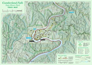
This July we have started a topographic trail map for the Cumberland Falls State Resort Park. The map will use aerial photography, 20-foot elevation contours, and GPS mapped trails. This two-sided 13.5″ x 19″ full-color map will show the entire park and connecting trails into the Daniel Boone NF, including Dog Slaughter Falls. This map is at 1:15,000 scale. The second map will zoom into the central area of the park and show trails at 1:5,000 scale. We anticipate this will be an awesome map, especially when used under a moonbow.

2013 Veterans Park Mountain Biking Trail Map

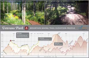
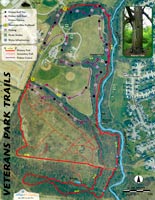
4.8-mile loop trail & out and back all on singletrack.

In tribute to Bike Lexington month, we’ve made a new map for beginning mountain bikers. If you’re new to trail riding and want tight, banking turns on fast, easy trail, then visit’s Lexington’s Veteran’s Park.

We created this map as a demonstration of small-area map making. We first walked the trail with a Trimble GPS unit this past winter to accurately locate the trail. We then used Kentucky’s new aerial photography and LiDAR elevation data to make 5-foot contours and heads-up digitized canopy coverage. We also pulled in the impervious and waterbody layers from the new Open Data Portal from LFUCG. This is all GIS data that has been created and/or made available in the past six months.

More nerd alert. The recent availability of small-scale mapping data is awesome. We thought we’d try to see how good this data is and make trail elevation profiles, which is included with this map. While the elevation profile is not perfect at this scale (with perhaps a +/- 8 ft height error for any given point on the profile), it gives a good distance measurement and represents well the relative slope of the trail. Since the vertical scale is not the same as the horizontal scale, the profile exaggerates the pumps & humps a rider faces…which means, the slopes are exaggerated.

Enjoy and tell us what you think.

Panama Adventure Hiking Elevation Profiles

Elevation profiles for adventure hiking.

Elevation profiles for adventure hiking.

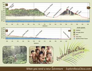
Looking for a spring adventure? We designed a website and these elevation profiles for a client that creates custom tour packages for Boca Chica, Panama. Below are descriptions of a few tours one could enjoy before the rainy season.

Amistad Adventure Trek
Hike a truly unique and extreme jungle trail from the cloud forests to the Caribbean lowlands in this united National Park of Panama and Costa Rica. A 42-kilometer trek with 2,500 meters terrain relief that you hike in 3 days.

Comarca Adventure Trek
Explore remote forested regions and Caribbean slopes of the Panama cordillera. A 46-kilometer trek with 1,300 meters terrain relief that you hike in 4 days. The trail is filled with amazing views, steep climbs and descents as you traverse the footpaths of the Ngabe Indian Reservation.

When you need a new adventure, ExploreBocaChica.com

Carter Caves Trail Map

Carter Caves State Resort Park Trail Map. 1:16500 scale with Tygarts State Forest. Click to download PDF.

This topographic map shows official trails in the Carter Caves State Resort Park and neighboring Tygarts State Forest. The map contains detailed trail descriptions and an inset map for the trails around the campground and lodge. A one-color free version of the map is available at the park visitors center. A full-color map is available for purchase or download a digital copy here.

Rephotographing Lexington’s Streetscapes

Rephotographing Lexington’s Streetscapes. Click to view Google Map.

A collaborative final project for GEO 172, Introduction to Human Geography, Fall 2012, BCTCS

The class was tasked with rephotographing the streetscapes of downtown Lexington captured by Asa Coleman Chin in 1920-1921. Sanborn maps of the areas Chin photographed are provided as a reference.

Students then researched Lexington newspapers for information about city life during the period 1907-1921. Historic themes of urban improvement, segregation, and riots emerge. Students’ photographs & research show monumental change in areas of civic life, but often little change in many areas of the city’s built environment.

Sources: Kentuckiana Digital Library & Lexington Public Library

2012 Bike Lexington Map

This map is freely available at local bike shops and as an electronic download.

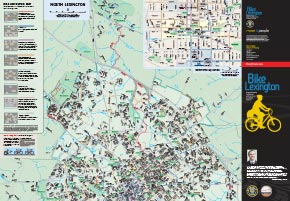
We are proud to announce the release of the Bike Lexington Map which locates bicycling facilities and preferred routes in Lexington, Kentucky. The purpose of the map is to show existing facilities (such as bike lanes and shared-use paths) and preferred routes (wider roads with low volume and/or low speed)  to encourage cycling and help cyclists plan trips through the city.

This 27″ x 39″ free, full-color map can be found at local bicycling shops and the Bread Box’s Broke Spoke and West 6th Street Brewing. UK students can pick up the map at Wildcat Wheels. Other outlets are sure to be added.

Digital PDF copies are offered in a few versions.

  1. The official map (7 megabytes) is the version printed.
  2. A map with aerial photography (49 megabytes) shows the built environment and surrounding countryside.
  3. A map book (27 megabytes) allows for easier printing and mobile use.

First Frontier Audio Driving Tour

Download and print the two-hour audio driving tour.

What trails will you blaze through this new frontier?

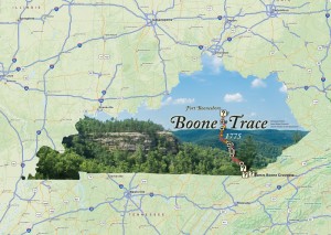
You will travel over ancient buffalo traces and Native American trails that frontier settlers cut into roads seeking the fertile lands of Kentucky. You will walk through Cumberland Gap where the Wilderness Road and the Warrior’s Path meet and look out upon America’s First Frontier. Along the Kingdom Come Scenic Parkway, you will hear the rushing headwaters of the mighty Cumberland River.

Download Hi quality (220 meg)

For adventuresome spirits, the unexplored road lures you to rugged mountain settlements and luxuriant coves of rhododendron blooms. Autumn hues of amber and scarlet sweeten your memories of fall vacations. Springtime stirs enchanting old-time songs and the colors of redbuds and dogwoods in our mountain festivals.

Website

Kentucky Boating Access Sites

Kentucky Boating Access Sites: one Texas-rigged publication!

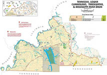
This publicaiton was commissioned by the Kentucky Department of Fish and Wildlife and was offered freely at places throughout Kentucky where one could buy a fishing license. The 11′ x 17′ booklet is no longer printed, but you can download full resolution PDFs from this site. The publication primarily shows public boat ramps and access sites on Kentucky’s lakes and rivers. It also shows stocked trout streams and favorable waters for other species. If you’ve ever fished with a texas-rigged worm, this is your book.

Veterans Park Frisbee Golf Course

Veterans Park Frisbee Golf Coursr

Since the building of Veterans Park’s new mountain bike trails, this map is no longer completely accurate, except for the frisbee golf course. So if you like to throw the plastic disks, then you have a map here.

John’s Run Walk maps

Three running routes around Chevy Chase

Street map for southeast Lexington with 10-foot elevation contours

Often folks wonder were to run in Lexington, especially after purchasing some fast and fly sneakers. These two maps present options for the runner. The first map locates three routes that verteran runners use for safety, scenery, and distance. The second map is simply a topographic street map for southeast Lexington inside New Circle.

At Leisure’s Edge

At Leisure's Edge

Download audio documentary (66 Megabytes)

At Leisure’s Edge, an audio exploration of Kentucky’s historic black parks. This download contains maps and audio that locate and describe Kentucky’s once-segregated black parks, including Cherokee State Resort Park in western Kentucky.

Have a listen to the Introduction.

Read the  Script-Radio-Documentary and visit the SoundCloud set.

Maps: InfoSheet and InfoSheet-Map

Or watch a one-hour documentary.

0

Your Cart