It’s time of year when the morning glories bloom in full, locusts buzz softly with early sunsets, and the promise of drier, cooler days ahead stirs images of woodland travels. Come on down to the Woodland Art Fair this weekend to get some park trail maps and discuss our new projects. See you there, August 20-21. We’ll have lemonade, too!
Archives of stuff
July 4, 2011 by Leave a Comment

Visit our site from 2004

Archive from 2011
Just for fun, we have added portions of our site from the old days of 2004 and 2011. Much of the content is duplicated, but it shows the evolution outrageGIS.com. If you want to go wayback, you need the wayback machine internet archive for our site. It should be noted that many links may be broken and contact forms will not work, since the emails have changed. If you need to contact us now, please use this link.
Road Closure Info for the Great Smokies
April 13, 2011 by Leave a Comment
Planning a spring trip to the Great Smokies? We’ve collected and posted official updates on road closures on our weather page.
A day of weather in the Great Smokies
March 6, 2011 by Leave a Comment
A somber late-winter day from Look Rock mountain overlook, March 5, 2011. [Read more…]
Town Branch Trail
February 18, 2011 by 1 Comment
A map of the 2.2 miles of trail, including the connector trails from surrounding neighborhoods. Visit Town Branch Trail (townbranch.org) to learn more about Lexington’s historic stream, Town Branch, and the greenway trail that is slowly building along it’s banks. [Read more…]

Bike Lex Map in draft
January 8, 2011 by Leave a Comment
 After a few grueling weeks of cartography, we have posted a draft of the new Bike Lex Map. The goal of this map is to help pedestrians and bikers enjoy the public spaces of central Lexington, Kentucky. The map should also help veteran bikers find new biking routes through the city and direct newbie bikers to good resources about biking in the city. Parents will also find the map helpful, because we have mapped many of the public parks and their paved paths. They can discover a new park to take their child’s first bike!
Proposed format: 26″ x 40″ printed map and companion website. Samples can be found here: http://www.bikelex.com
What does this map offer?
- Alignments for the Legacy Trail, Town Branch Trail, and other shared-use trails.
- Mountain biking trails in Veterans Park.
- Bike lanes & shoulders, walking paths, unpaved foot & bike trails, and other paths & spaces pedestrians might enjoy.
- Best routes for biking on Lexington streets.
- University of Kentucky bike routes.
This guide is in the early stages of development. If you would like to contribute, please contact us with your opinions, suggestions, or requests.
Thanks and happy trails!
Archive of Webcam Animations
September 17, 2010 by 1 Comment
In the spring of 2009, I wrote a couple scripts to automate collecting webcam and visual satellite images of the Great Smoky Mountains National Park and creating animations from them. Recently I put the archive of those animations online after a few requests. The archive also records the past 24-hour temperatures, precipitation, and snow depth for the day selected.
Questions like, when’s a good time to see fall colors, can be now be answered with a visual assessment from last year’s observations. Combare the days between October 10 and October 22, 2009, for a good answer. Between those days, the smokies received its first snowfall.
The archive can be found here: http://www.outragegis.com/weather/img/animation
Woodland Art Fair this weekend!
August 20, 2010 by Leave a Comment
Come down to the Woodland Art Fair the is Saturday and Sunday and check out our new Great Smoky Mountains National Park map. Mention that you read this post on our News section and get $2 off any map purchase and a special gift. [Read more…]
Webcams for Great Smoky Mountains
July 31, 2010 by Leave a Comment
 After a few months of intermittent outage, the four webcams that cover the Great Smokies are all working. Now we can compare sky conditions on both sides of the mountain and also observe sunrise and sunset. The webcam animations also work, too!
You can view these webcams on our weather page: outrageGIS.com/weather/grsm
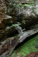
Furnace Arch, Sheltowee Trace
July 11, 2010 by 1 Comment
 Cave Run Lake Trail Guide
Distance: 6 Miles round-trip from trailhead
Difficulty: ++
Scenic Views: +++
Elevation Relief: 500ft ^
Ownership: Daniel Boone NF, USFS
| Sheltowee Trace North Trail Map |  |


Imagine the scene around Clear Creek Iron Furnace in the 1830’s, the trailhead for this hike. Scores of men were clearing old growth trees by acres a week, cutting limestone from the creeks, and hauling iron ore rock from neighboring hillsides to fuel one of largest iron furnaces in Kentucky. Iron was produced roughly nine months out of the year. The process was a laborious affair, but the profit was great until much larger deposits of iron ore were found in the southern Appalachians and around the Great Lakes.

The cut wood was slowly burned in dirt covered pit to make charcoal. The furnace was ‘charged’ from the top in layers of ore, charcoal, and limestone and when full, the furnace was stoked with forced air until the charcoal was white-hot and the whole furnace roared tremendously and blasted heated air, flames, and a shower of sparks from the top. That’s when the furnace was in blast and slowly molten iron would flow from furnace bottom and fill trenches of sand to make pig iron ingots. The iron ore found in rocks is basically rust and is rendered as elemental iron in series of chemical reactions in the furnace.
Today you can still see many aspects of the furnace operation. The hand-cut limestone furnace still stands. Glass and slag are found downstream. The fuel for charcoal of course grows around abundantly. The limestone outcrops as you ascend the trail south from furnace. The Sinks is a sinkhole in the limestone bedrock produced by the slow process of erosion. Atop the southern extent of this trail, you’ll find the same rugged sandstone the produces the great rockshelters in the Red River Gorge. In fact, if you continue hiking the Sheltowee Trace south, you’ll travel through the heart of the Gorge.
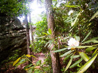
Furnace Arch is a low broad arch that resembles the iron furnace in shape. The sandstone outcrops in the area offer a few campsites, though no water along the ridge top. The scenic quality of this area, with blooming rhododendron against craggy boulders, is worth a day of exploration.
D. Boone Hut Trail
June 18, 2010 by Leave a Comment

 Red River Gorge Backpacking Map
Distance: 1.5 Miles loop trail
Difficulty: ++
Scenic Views: +++
Elevation Relief: 400ft ^
Ownership: Daniel Boone National Forest, USFS
| Red River Gorge Backpacking Map: $14 | |
 A hike from Gray’s Arch Trailhead to D. Boone Hut and Martin Fork. A large area of ferns can be found on near the crossing of Martin Fork and scenic overlooks offer limited views down the valley and across the valley to Tunnel Ridge Road.
[Read more…]
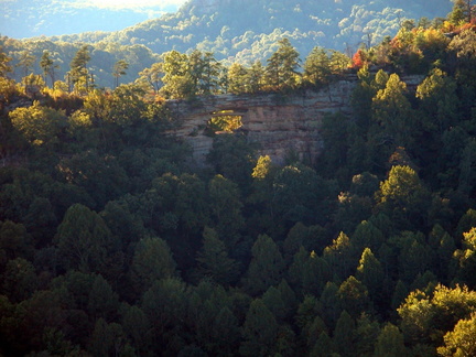
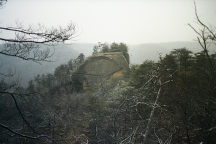
Auxier Ridge & Double Arch Trails
June 17, 2010 by Leave a Comment
Red River Gorge Backpacking Map
Distance: 3.2 Miles loop trail
Difficulty: ++
Scenic Views: ++++
Elevation Relief: 400ft ^
Ownership: Daniel Boone National Forest, USFS
| Red River Gorge Backpacking Map: $14 | |
 Double Arch
Auxier Ridge is one of the great hiking areas in the Red River Gorge. Hikers have two loop options here. First, you can hike out the Ridge on trail #204, passing some excellent scenic overlooks, and return on Trail #202, Courthouse Rock trail. The second option is to return by way off Auxier Branch Trail, #203, with a side trip to Double Arch. This second option uses the closed Tunnel Ridge Road to connect back to the trailhead.
 Courthouse Rock
[Read more…]
Rock Creek Loop, a cool summer hike
June 15, 2010 by Leave a Comment
 Big South Fork Map
Distance: 6.6 Miles round-trip
Difficulty: ++
Scenic Views: +++
Elevation Relief: 520ft ^
Ownership: Big South Fork, NPS
| Big South Fork Trail Map: $12 | |
Hike the scenic crossroads of the John Muir Trail and Sheltowee Trace. Rock Creek Loop is a 6.6-mile loop in our Big South Fork Guide. Half of this loop follows the cool waters of Rock Creek, a trout stream with small stretches of swift water and deep pools for summer refreshment.
Hikers weave through a forest dominated by old, stately Hemlock and American Beech trees with grassy, wildflower areas along the stream bank. The trail is a rugged footpath with a bridge across Massey Branch. Numerous backcountry campsites along the loop offer great weekend backpacking options with side trail options into Pickett State Park and the Daniel Boone National Forest.


You must be logged in to post a comment.