Current Observations

North Daniel Boone Country
Fair and 70 F at Lexington Blue Grass Airport, KY

Fair Winds are Northeast at 8.1 MPH (7 KT). The pressure is 1010.6 mb and the humidity is 35%. Last Updated on Jun 8 2023, 10:54 am EDT.

Central Daniel Boone Country
Fair and 66 F at London, London-Corbin Airport-Magee Field, KY

Fair Winds are Variable at 3.5 MPH (3 KT). The pressure is 1010.2 mb and the humidity is 63%. Last Updated on Jun 8 2023, 10:53 am EDT.

South Daniel Boone Country
Fair and 65 F at Monticello, Wayne County Airport, KY

Fair Winds are Calm. The pressure is 1011.2 mb and the humidity is 78%. Last Updated on Jun 8 2023, 10:56 am EDT.

Current webcam for Daniel Boone Country.
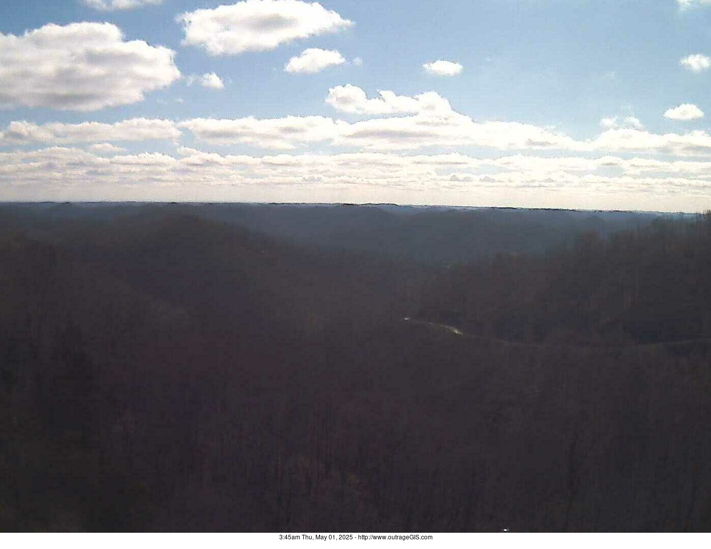
Current webcam: Enlarge

Why are the images dark? It's nightime Daniel Boone country! Photo is realtime webcam from the National Weather Service station in Jackson, Kentucky.

Latest update local time: 2:30pm Thu, Jun 08, 2023 - http://www.outrageGIS.com

Current visible satellite for the Daniel Boone National Forest.

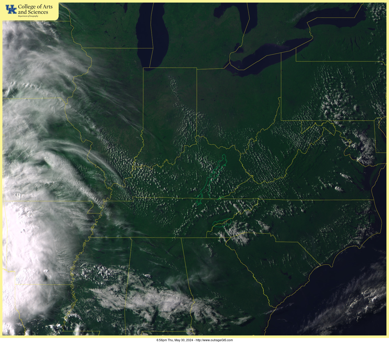
Daniel Boone Visible Satellite

Enlarge

Current doppler radar for the Daniel Boone National Forest.
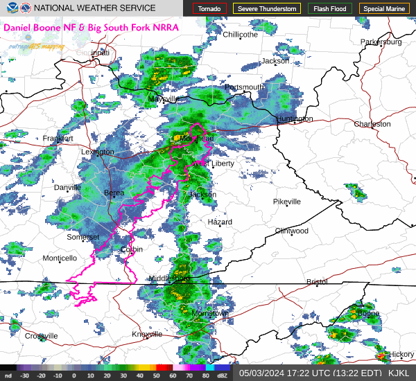
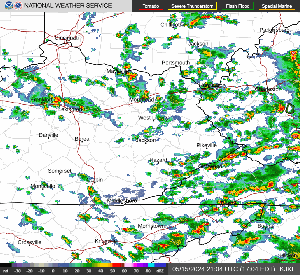
Daniel Boone Doppler Radar 

Enlarge | Animate | Doppler Radar FAQ from NOAA

Composite doppler radar for Kentucky.
Current regional Radar: Enlarge | Animate

More about doppler radar images on NOAA's website. Broad circular areas of cyan & blue should not be interpreted as precipitation on this composite radar. 

Current National Weather Service watches and warnings.
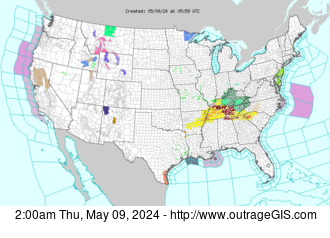
Current Watches & Warnings: Enlarge

Daniel Boone Weather on NOAA's website 

Current surface observations
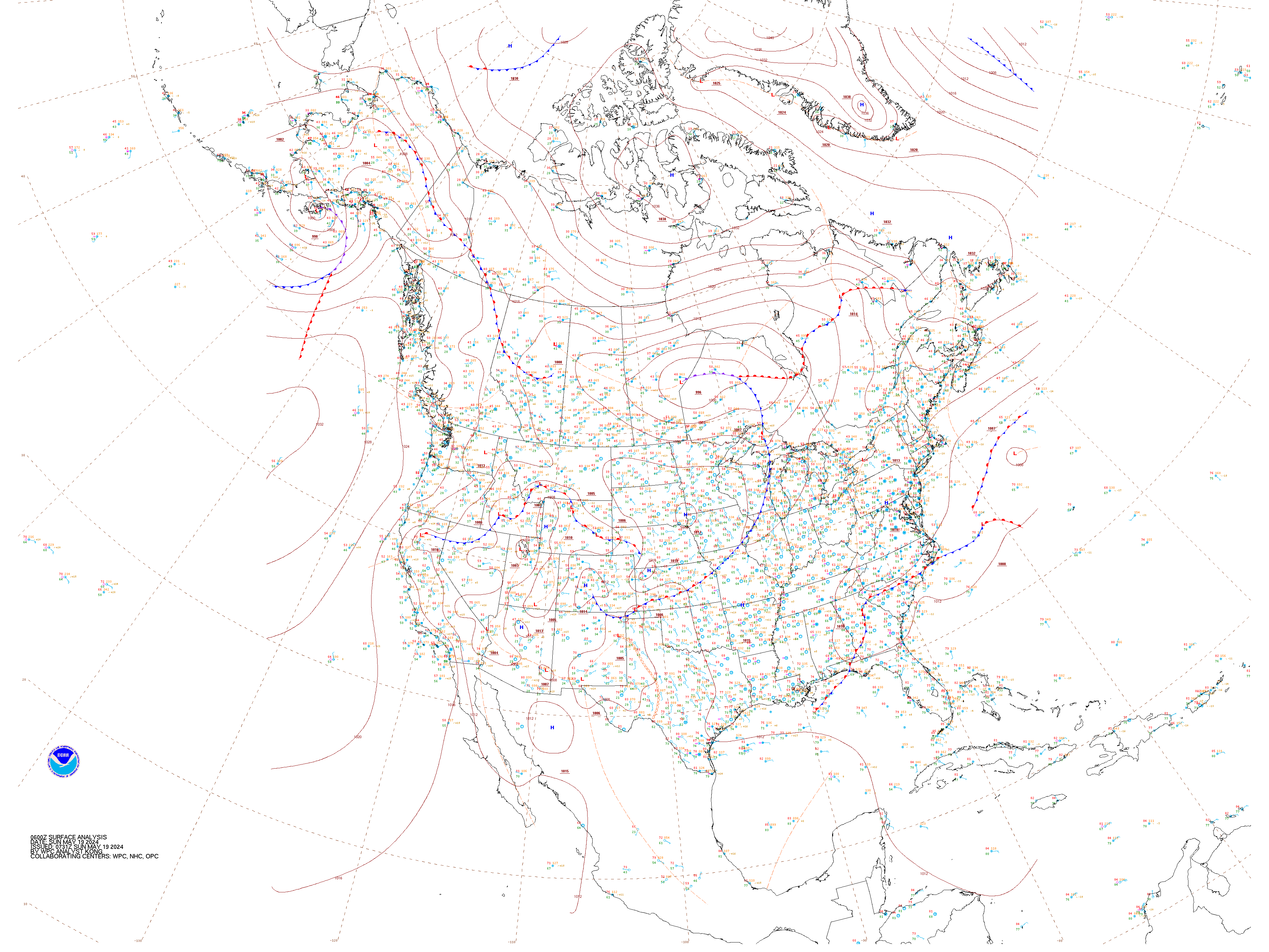
Current Surface Weather Observations: Enlarge

Print key for weather station data. Please note that this map gives station observations for only temperature, wind speed & direction, cloud cover, and weather condiitons. 

Daniel Boone Country radar

Enlarge

Red River Gorge Forecast

7-Day Forecast 37.78°N 83.67°W (Text-Only)
NWS Forecast for: 2 Miles ESE Slade KY
Issued by: National Weather Service Jackson, KY
Last Update: 1:59 pm EDT Jun 8, 2023
  • This
    Afternoon

    This Afternoon: Widespread haze. Sunny, with a steady temperature around 72. North wind around 7 mph.

    Haze


    High: 72 °F

  • Tonight

    Tonight: Widespread haze. Mostly clear, with a low around 46. North wind around 6 mph becoming calm  in the evening.

    Haze


    Low: 46 °F

  • Friday

    Friday: Widespread haze before 3pm. Sunny, with a high near 76. Northwest wind 3 to 7 mph.

    Haze


    High: 76 °F

  • Friday
    Night

    Friday Night: Clear, with a low around 50. Light and variable wind.

    Clear


    Low: 50 °F

  • Saturday

    Saturday: Sunny, with a high near 83. South wind 3 to 6 mph.

    Sunny


    High: 83 °F

  • Saturday
    Night

    Saturday Night: Mostly clear, with a low around 56.

    Mostly Clear


    Low: 56 °F

  • Sunday

    Sunday: A chance of showers before 2pm, then a chance of showers and thunderstorms between 2pm and 4pm, then showers likely and possibly a thunderstorm after 4pm.  Mostly sunny, with a high near 85. Chance of precipitation is 60%.

    Slight Chance
    Showers then
    Showers
    Likely

    High: 85 °F

  • Sunday
    Night

    Sunday Night: Showers and possibly a thunderstorm.  Low around 62. Breezy.  Chance of precipitation is 90%.

    Showers and
    Breezy


    Low: 62 °F

  • Monday

    Monday: Showers likely and possibly a thunderstorm before 2pm, then a chance of showers.  Partly sunny, with a high near 74. Chance of precipitation is 70%.

    Showers
    Likely


    High: 74 °F

  • This Afternoon: Widespread haze. Sunny, with a steady temperature around 72. North wind around 7 mph.

    Tonight: Widespread haze. Mostly clear, with a low around 46. North wind around 6 mph becoming calm in the evening.

    Friday: Widespread haze before 3pm. Sunny, with a high near 76. Northwest wind 3 to 7 mph.

    Friday Night: Clear, with a low around 50. Light and variable wind.

    Saturday: Sunny, with a high near 83. South wind 3 to 6 mph.

    Saturday Night: Mostly clear, with a low around 56.

    Sunday: A chance of showers before 2pm, then a chance of showers and thunderstorms between 2pm and 4pm, then showers likely and possibly a thunderstorm after 4pm. Mostly sunny, with a high near 85. Chance of precipitation is 60%.

    Sunday Night: Showers and possibly a thunderstorm. Low around 62. Breezy. Chance of precipitation is 90%.

    Monday: Showers likely and possibly a thunderstorm before 2pm, then a chance of showers. Partly sunny, with a high near 74. Chance of precipitation is 70%.

    Monday Night: A 30 percent chance of showers, mainly before 9pm. Mostly clear, with a low around 54.

    Tuesday: A 30 percent chance of showers and thunderstorms. Sunny, with a high near 77. Windy.

    Tuesday Night: A 30 percent chance of showers and thunderstorms. Partly cloudy, with a low around 59.

    Wednesday: A 20 percent chance of showers and thunderstorms. Mostly sunny, with a high near 83.

    2 Miles ESE Slade KY
     37.78°N 83.67°W (Elev. 997 ft)

    Visit your local NWS office at: https://www.weather.gov/jkl


    Big South Fork Forecast

    7-Day Forecast 36.46°N 84.67°W (Text-Only)
    NWS Forecast for: 6 Miles WNW Helenwood TN
    Issued by: National Weather Service Morristown, TN
    Last Update: 1:13 pm EDT Jun 8, 2023
  • This
    Afternoon

    This Afternoon: Widespread haze. Sunny, with a high near 76. North wind around 5 mph.

    Haze


    High: 76 °F

  • Tonight

    Tonight: Widespread haze. Mostly clear, with a low around 46. North wind around 5 mph becoming calm  in the evening.

    Haze


    Low: 46 °F

  • Friday

    Friday: Widespread haze. Sunny, with a high near 79. Calm wind becoming north around 5 mph in the afternoon.

    Haze


    High: 79 °F

  • Friday
    Night

    Friday Night: Clear, with a low around 49. North wind around 5 mph becoming calm  in the evening.

    Clear


    Low: 49 °F

  • Saturday

    Saturday: Sunny, with a high near 85. Calm wind.

    Sunny


    High: 85 °F

  • Saturday
    Night

    Saturday Night: Mostly clear, with a low around 57. Calm wind.

    Mostly Clear


    Low: 57 °F

  • Sunday

    Sunday: A chance of showers, then showers likely and possibly a thunderstorm after 2pm.  Mostly sunny, with a high near 84. Calm wind.  Chance of precipitation is 60%.

    Chance
    Showers then
    Showers
    Likely

    High: 84 °F

  • Sunday
    Night

    Sunday Night: Showers likely and possibly a thunderstorm.  Mostly cloudy, with a low around 61. Chance of precipitation is 70%.

    Showers
    Likely


    Low: 61 °F

  • Monday

    Monday: Showers likely and possibly a thunderstorm before 2pm, then a chance of showers and thunderstorms after 2pm.  Partly sunny, with a high near 78. Chance of precipitation is 60%.

    Showers
    Likely


    High: 78 °F

  • This Afternoon: Widespread haze. Sunny, with a high near 76. North wind around 5 mph.

    Tonight: Widespread haze. Mostly clear, with a low around 46. North wind around 5 mph becoming calm in the evening.

    Friday: Widespread haze. Sunny, with a high near 79. Calm wind becoming north around 5 mph in the afternoon.

    Friday Night: Clear, with a low around 49. North wind around 5 mph becoming calm in the evening.

    Saturday: Sunny, with a high near 85. Calm wind.

    Saturday Night: Mostly clear, with a low around 57. Calm wind.

    Sunday: A chance of showers, then showers likely and possibly a thunderstorm after 2pm. Mostly sunny, with a high near 84. Calm wind. Chance of precipitation is 60%.

    Sunday Night: Showers likely and possibly a thunderstorm. Mostly cloudy, with a low around 61. Chance of precipitation is 70%.

    Monday: Showers likely and possibly a thunderstorm before 2pm, then a chance of showers and thunderstorms after 2pm. Partly sunny, with a high near 78. Chance of precipitation is 60%.

    Monday Night: A 30 percent chance of showers and thunderstorms before 8pm. Mostly clear, with a low around 54.

    Tuesday: A 20 percent chance of showers and thunderstorms. Sunny, with a high near 80.

    Tuesday Night: A 20 percent chance of showers and thunderstorms. Partly cloudy, with a low around 57.

    Wednesday: A 30 percent chance of showers and thunderstorms. Mostly sunny, with a high near 85.

    6 Miles WNW Helenwood TN
     36.46°N 84.67°W (Elev. 1030 ft)

    Visit your local NWS office at: https://www.weather.gov/mrx


    Friendly Feeds

    Posts from SheltoweeTrace.com
    Veterans Day Hiking 2019
    Author: twostep Posted: Sat Nov 30, 2019 6:24 pm (GMT -5) Started on a hike before realizing it was deer season. https://www.youtube.com/watch...
    What happened?
    Author: Elkins45 Posted: Thu Mar 22, 2018 9:26 pm (GMT -5)
    Tweets from the STA
    News from the Sheltowee Trace Association about Kentucky's long trail, the Sheltowee Trace.
    Tweets from KyWilderness
    Activities in the great outdoors of Kentucky and beyond, focusing mainly on the Daniel Boone National Forest and the Big South Fork.

    Our Recent Photographs & Maps

    OWE

    OWE

    Cumberland Gap, ridge and v...

    Cumberland Gap, ridge and valley, and impact crater The interesting physiography of southeastern Kentucky and southw...

    Webcam Animations

    Archive of animations for the Great Smoky Mountains
    Great Smoky animations, updated daily (2015 to present)
    Go Explore!

    Our Favorite Hikes

    Furnace Arch, Sheltowee Trace

    aalCave Run Lake Trail Guide
    Distance: 6 Miles round-trip from trailhead
    Difficulty: ++
    Scenic Views: +++
    Elevation Relief: 500ft ^
    Ownership: Daniel Boone NF, USFS

    Sheltowee Trace North Trail Map

    Hiker Hiker Hiker

    Imagine the scene around Clear Creek Iron Furnace in the 1830’s, the trailhead for this hike...

    Maps and Weather

    Experimenting with Geolocat...

    We have a lot of great raster base map services available in Kentucky and I wanted to access them for my current location when I use my mobile device in the field. While there are many ways to make a mobile map, I wanted use Leaflet JS and build a custom geolocation service using the Geolocation ...

    Our Clients' Maps

    Johnson Highway Day Map
    Click to open map

    Click to open map

    On September 20, 2014 a downtown Lexington neighborhood hosted a block party and potluck. Raffles were held, which indeed included some outrageGIS mapping hiking maps. This map is entirely custom and shows only sidewalks and the location of the block party. The map layers two di...